


Meteorologist Cliff Mass Asks the Heated Question: Has Global Warming Changed the Nature of Northwest Heatwaves?
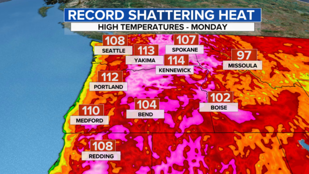
On July 9th, the temperature surged to 98F at Seattle-Tacoma Airport. This was a record for the day and 22F above normal.
But that is not what surprised me…..SeaTac had gotten that warm before.
It is was HOW it got that warm.

I have completed a lot of research on Northwest heatwaves and published roughly ten articles on this subject in the peer-reviewed literature. Historically, to get that warm in Puget Sound you needed easterly (from the east) winds over the Cascades, winds that descended the western slopes of the Cascades. (see schematic).
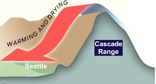
Easterly winds are good for Puget Sound lowland warmth in many ways. First, they remove the influence of the cool Pacific Ocean, which is only around 50F. Second, the air comes from the generally warmer interior of the continent. And finally, air sinking down the western sides of the Cascades warms by compression.
Strangely, the situation on July 9th did not fit the traditional heatwave situation.
Why?
Because there was little evidence of easterly flow. Seattle Tacoma Airport got very warm without the powerful assistance of atmospheric compression.
I was not a little bit shocked by this realization. Could I prove this was more than a fluke?
So I decided to do a little research…which I am going to write up this year. I found all the times when the temperatures at SeaTac reached 95-99F. (Remember that the highest temperature on record there was 108F in 2021).
Then I examined the regional weather patterns associated with the first five events at these temperatures and the last five events achieving the same (again 95-99). Here are the two collections of dates.
![]()
![]()
The first group occurred before global warming was significant.
The second group after human impacts would have been expected.
For each of these collections of dates, I found the average sea-level pressure patterns and 5000 ft winds (actually 850 hPa pressure winds).
The results were stunning.
Let me show you the upper level (again around 5000 ft winds) before and after global warming for such events. For the earlier events (below global warming, GW), major heatwaves required easterly winds (look at the little arrows). The shading gives the wind speed. After GW, the warming assist from strong easterly winds was not necessary.

Why not necessary? The atmosphere starts out warmer for a start, with summer temperatures now 2-3F warmer than 50 years ago. And there are other potential factors associated with global warming as well, such as drier soils and alternations of weather patterns. Furthermore, SeaTac Airport temperatures have undoubtedly been warmed by several degrees due to the construction of the third runway, airport development, and increased urbanization in the area.
Then I asked another question: What about the really extreme heatwaves, like the 2021 event where SeaTac got to 108F or the 2009 event where 103F was reached?
Do they require easterly flow?
I checked…..and the answer is yes. To get uber heat, an assist from downslope compressional warming is required.
Anyway, this is a fascinating topic: how are the weather patterns required for extreme heat changing? One I plan to examine in great detail.